 Travelling in 3D -- A review of OnCourse Navigator 8
Product Category: Road Navigation software
Manufacturer: NavNGo
Where to Buy: Easy PocketNav Inc.
Price: $75.00 USD on 2G microSD card with adapters; 4G and 8G versions also available
System Requirements: WM5.0 or 6.0, 400Mhz processor, 64M memory (128M recommended)
Specifications: Approx 1.2Gb of map and POI data; over 12.3 million POIs; maps include Canada, US, Hawaii, Alaska and Puerto Rico; Supports all VGA and QVGA screen resolutions; 30 language support with over 50 profiles.
Pros: - Seamless maps for door-to-door interstate/province mapping for USA and Canada;
- Smart Zoom feature is very useful, especially on longer trips;
- Quick route calculation & rerouting, with selection between alternative routes, depending upon your preferences.
Cons: - Product activation/licence is hardware tied to the specific card;
- No notification of processing/translating Outlook Contacts at initial startup;
- Some icons on the navigation screen are too small to be visable/usable.
Summary:
When looking for navigation software for the Windows Mobile platform, there is certainly no shortage of options. TomTom, Garmin, iGuidance, CoPilot, Ostia, Google Maps (if you are lucky enough to have an unlimited data plan) are among the better known alternatives here in North America. In Europe and Asia, the options become almost mind boggling. On Course Navigator is the North American package for iGo, one of the most popular personal navigation systems in Europe. We took a look at OCN6 about a year ago, and now Pocket EasyNav, the North American distributor has just released OCN8. The screenshots and brochures show a lot of 3D rendering of buildings and terrain but how does this affect performance? Let's take it out for a spin...
Introduction
Well, it was only a year ago that our own Doug Raeburn posted his very complete review of OnCourse Navigator 6.
At the time, we were pretty impressed by the interface and the range of features supported. About three months ago, NavNGo, the developer, released iGo 8 to the European market and now the North American version OCN8 is available. According to Easy PocketNav, the delay was partly due to Americanizing the software, and wanting to wait for some bug fix patches to be included before release. So, what's new in this version? The big differences are: - completely redesigned interface;
- 3D map graphics, including buildings and terrain;
- simple vs. advanced mode;
- POI search around current position, current cursor, along current route;
- full screen route display; and
- text-to-speech (available separately).
I've had the software for about a month now and have been able to test drive most of these features on a variety of trips. Nothing cross-continent mind you, but a good mix of urban, suburban, and country/remote routes which provide a good feel for the software and the maps included. I've tried a lot of different navigation systems, but I keep coming back to OCN. It's very feature-rich, has an interface design which doesn't require the stylus, and always contains the most accurate and current maps for my area. Installation
OCN8 comes standard on a 2G microSD card with mini- and standard-SD card adapters included. (4G and 8G versions are also available to give you additional room for other software, music, etc.) The card includes all the maps for Canada, the continental US, Hawaii, Alaska and Puerto Rico. In terms of card content, each geographic area has four map files: - road network;
- points of interest (POI);
- buildings; and
- terrain and elevation.
For the US, there is one set of maps for each of the states while the whole of Canada is covered by one (albeit somewhat larger) single set. The advantage of this configuration over the ones I've seen from other map distributors, is that if you need to clear out some space on the card, you can backup the content of the card to a PC or other hard drive and then delete the files for locations you don't normally travel through. You can always add them back later, and OCN automatically includes them in routing, display, etc. Installation of OCN8 is identical to OCN6 and couldn't be simpler. Pop the card into the slot and tap 'Yes' to install. That's it -- no licensing or activation codes to request or type in, no maps to download, identify or add. You can even install to multiple devices if you wish. Unfortunately, this simplicity and flexibility comes at a price. As with OCN6, the licensing/activation information is built into the card's hardware, so you have to use the card provided to run the program. If the card gets damaged or unreadable (as happened to me with OCN6) you need to return it to Easy PocketNav for a replacement. I did this, and they provided a new card free of charge. The only cost to me was shipping to California. By default, after installation of the software, OCN starts up automatically and immediately begins scanning your Outlook Contacts, attempting to create POIs for each of them. (If you don't need your Contacts as POIs, there is a configuration parameter in the startup SYS.TXT file you can set to turn this function off.) Unfortunately, OCN doesn't tell you that's what it's doing. The process is extremely processor intensive and basically brings the system to its knees for between 10 and 40 minutes, depending upon how many contacts you have. Fortunately, this only happens the first time you install OCN on the Pocket PC and my suggestion is to just be patient. Once it has completed its translation, it will display a screen telling you how many it was able to successfully do, and how many it found 'errors' with. Typically, the errors are situations with a missing zip code, or incomplete address, or addresses in two different locations and it will allow you to go through each one and select the appropriate alternative. Fortunately, the Outlook Contacts locations and OCN preferences seem to be retained as files on the card itself, so when you re-install after an upgrade or install to a new unit, don't need to go through this lengthy setup process again. New Look and Feel
NavNGo has completely redesigned the look and feel of OCN for this latest version. While the terminology and functionality will be familiar, a great deal of effort has been put into making the screens finger-friendly so there is no need for the driver/navigator to use the stylus at all. The menu structure has been flattened and better organized to make it easier to get to functions and settings. OCN8 also introduces the concept of Simple and Advanced modes of interaction. The Simple mode provides a very straightforward menu path to the basic functions of a navigation system: Define a destination and follow the fastest route available to get there. 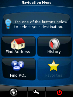
Figure 1: Main menu when in Simple Mode. Note the big buttons and icons to make it easy to access with a finger (or thumb!) touch at a quick glance. The Favorites option is greyed out because I haven't defined any yet!
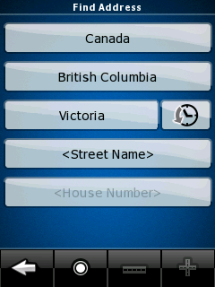
Figure 2: Finding an address. Just provide the street name and house number and away you go. You can also just provide the street name, and OCN will come back with a list of interesecting streets from which you can choose.
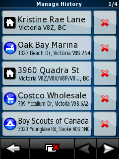
Figure 3: History - You can also select from a list of places you've already visited.
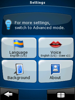
Figure 4: The settings menu in Simple mode shows you the current setting values. If you want to change any one of them, you just press on the button.
The Advanced mode gives the user a more in-depth menu system with access to all the features available. These include: - multi-point routes;
- saving map points as POI or Safety Camera position;
- saving routes;
- saving track logs;
- speed and camera warnings; and
- navigation to coordinates.
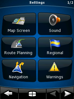
Figure 5: The main settings screen in Advanced Mode.
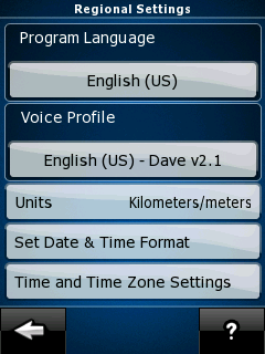
Figure 6: The Regional Settings screen. Note how the need to scroll down to get at further settings has been eliminated from this version.
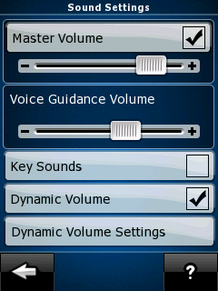
Figure 7: Sound settings. Dynamic Volume refers to tailoring the volume of announcements to the ambient noise in the vehicle at various speeds. Typically, there is more noise when traveling faster, so the announcements need to be louder.
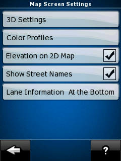
Figure 8: Map Screen settings. Here, you can configure the map/navigation screen to your preferences.
As you can see from the screens, everything is pretty much available within 2 or 3 taps which is a big advantage over OCN6. NavNGo has also made extensive changes to the Navigation screen itself in this version. There is less information shown directly on the screen than previously, but all the data is quickly available by tapping on 'active' areas/icons on the screen. It took a little while to get used to pressing on certain guages and icons to get more information in specific areas, but all the connections are very intuitive. There has also clearly been a lot of thought put into usability and layout in both Portrait and Landscape modes. Rather than just flipping the screen onto its side, NavNGo has designed distinctly different layouts for each mode, to make best use of the available real estate. 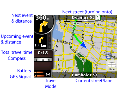
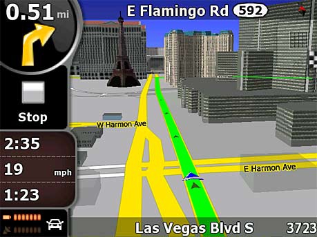
Figure 9: Here's the new navigation screen interface in Landscape mode. I've added labels to describe each of the icons shown. The big blue arrow in the centre is your current position. The thick green line is your current route.
Almost all of the icons are active and provide additional detail screens when tapped. The Menu button in the lower right takes you back to the main menu of OCN. The 'ghosted' buttons above it allow you to reset the centre of the map, define a detour from the current route, and switch to 3D display mode. You can probably only just barely see them, but just beside the Upcoming event and distance arrow (with the 7.4km underneath) are three icons to show you the status of the bluetooth connection to your GPS device; TMC channels; and volume of notifications of events. They are greyed out/dim here because none of them are active on my unit, but even when they are active -- like when you turn off the notifications -- the icons are way too small to be visible or useful. 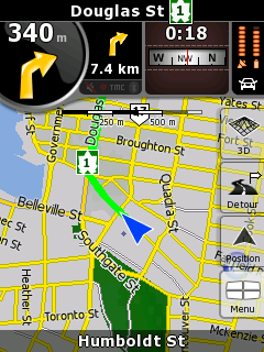
Figure 10: Here's the same navigation screen in Portrait mode. The buttons on the right side are more visible now, but will grey out after a few seconds. Notice how the Upcoming Event icon has been moved (along with everything else) up to the top of the screen. For me, I find this layout confusing because on a quick glance, it appears I have 7.4km before turning onto Douglas Street.
When traveling at night, OCN automatically switches to colours and intensity which are a little easier on the eyes in a darkened vehicle. They've softened them somewhat from OCN6 -- focusing on blues, greys and whites. You can also set the screen brightness for night operation separately from the normal day use. 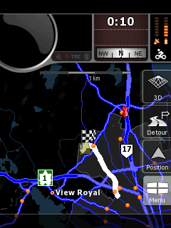
Figure 11: The navigation screen showing a full route display at night. The colours are muted, but very visible in a darkened vehicle, and you can also configure the overall screen brightness for night mode as well.
Tapping on the map itself allows you to either select a point for more information, or to set it as a destination, or if you tap and hold, a set of icons will be displayed along the bottom to zoom in and out. 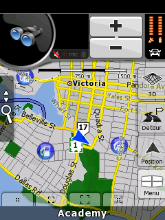
Figure 12: Zoom icons along the bottom allow you to zoom in or out to preset levels, or use the automatic 'smart zoom' feature, depending upon the distance to the next event. The +/- icons at the top allow you to zoom in as much as you like.
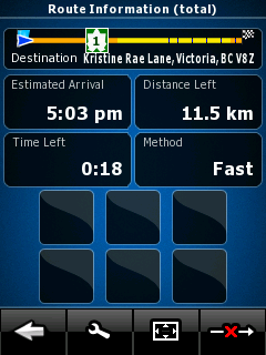
Figure 13: Total Route Information, displayed when you press the Next Event and Distance icon. The black boxes near the bottom would show any restricted travel areas (unpaved roads, toll roads, ferries, etc.) which were included in the route.
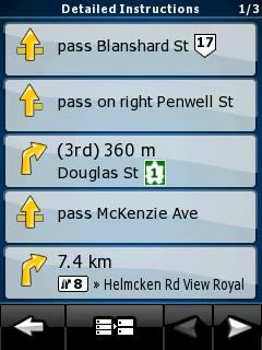
Figure 14: Detailed Route Instructions, displayed when you press the Upcoming Event and Distance icon.
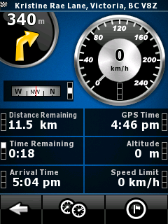
Figure 15: Trip Details screen, displayed when you tap on the Compass.
...and tapping on the speedometers at the bottom of this screen takes you to... 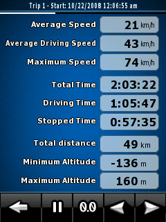
Figure 16: One of three trip computers available within OCN8.
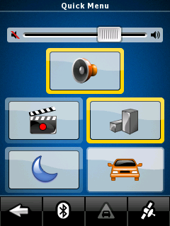
Figure 17: Quick Menu -- accessible by tapping the Battery/GPS/Travel Mode icon.
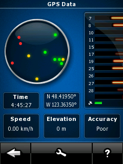
Figure 18: ...And just one more tap of the satellite on the previous screen brings you here, to the GPS data screen.
Some of the options in the navigation screen of OCN6 have been removed. Now, in OCN's 2D map mode, it automatically runs with North always up. In 3D mode, the map is automatically rotated in track up mode (i.e. the vehicle is always travelling up the screen.) There isn't an option to change these. One of the big features touted for this version of OCN is 3D rendering of buildings and terrain to provide a more natural driving view. Unfortunately for me, the buildings and terrain information is only available for major cities in the US, not for Canada (yet, I hope). So, for now, you'll just have to take a look at the examples provided on the website. OCN also provides a Safety mode if you feel the need for it, which will inhibit all interaction while it detects the vehicle is going over 10mph. This version of OCN provides a few more vehicle types -- adding pedestrian and bicycle. The main difference between these is the effect on routing. When you are a pedestrian or bicycle though, OCN turns off the automatic road centering feature and simply places you wherever the GPS says you are on the map. 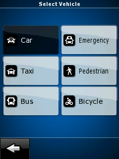
Figure 19: OCN adjusts your route based on the type of vehicle you are.
Navigation
Navigation in OCN8 is pretty straightforward, as it was in OCN6. To get going, you simply define your destination via POI, address, intersection, GPS coordinates or a point on the map; select 'Set as Destination' and away you go! OCN automatically calculates a route based on your current position (or your last recorded position). 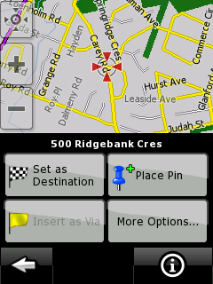
Figure 20: Defining a route. You tap on the map and define what this point is.
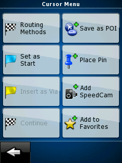
Figure 21: If you want this to be a start point, here's the options screen (available from the screen above) to select that.
What makes this software much more powerful as a route planner is the ability to set not only the destination, but a different starting point, and multiple 'stopover' or via points along the way. OCN allows you to define these multi-point routes in two ways. Starting with an existing route (start point and destination), you can either extend the route by adding a new final destination (so the original one becomes a via point) or by inserting an via point in the route, retaining the original destination. 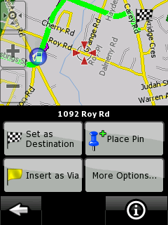
Figure 22: Here, we've selected another point away from the current route and insert it as a Via. If we set this as the new Destination, then OCN asks if you want to drop the previous Destination or create it as a Via in the new route.
OCN8 comes with new, version 2 voice profiles which have much smoother turn-by-turn event/instruction prompts. Using the Dave profile, I didn't notice obvious places there the prompts were spliced together and altogether the effect is much more natural. There is also a much better array of instructions, such as "take the 2nd exit in the roundabout" and "drive straight through", which come at just the right time to encourage confidence that everything is under control. The driving portion of turn-by-turn navigation is the same as in OCN6, with events being announced 800m, 300m, 100m and at the intersection. Personally, I find the 300m a bit of overkill, but in some situations it can be helpful. Unfortunately, OCN also reacts very quickly to changes in GPS position/lock. If the GPS signal is a little weak and there isn't a good 'lock' on the satellites, it can get confused as to position and direction, which translates to confusing or conflicting instructions. As I've said in other reviews and many forum postings, all navigation software is only as good as the maps it comes with. This version of OCN8 comes with fairly recent maps -- updated as of April 2008 -- from TeleAtlas. Overall, they are pretty good and NavNGo is in the process of developing an update website from which you can order and install updates to your maps, POIs, and 3D features. It's just in beta mode right now, so we'll have to see where it goes from here. The challenge in dealing with errors is discovering if you have a problem with the map or the navigation software's interpretation of it. For me here in sleepy Victoria, there were a couple of instances of map mistakes where a turn was not identified as such, even though there is an intersection with a light. Also, no house #'s were associated with my cul-de-sac, so I can only navigate to the middle of the road leading up to it. It's not a big deal, since TeleAtlas provides a web site where you can report such errors and provides feedback on all reported problems. The OCN8 application takes quite a bit of processing power, so depending upon the version of your O/S, you may or may not be able to run other applications or even answer incoming phone calls while in Navigation mode, even with OCN minimized. I did have a couple of instances where phone calls simply went away while navigating, but on the whole, things have been very stable. The Smart Zoom feature is one that I haven't seen on a lot of other nav applications, but I really like it on longer trips. When you are greater than 5km from the next turn, smart zoom flattens out to 2D map mode and zooms out to show progress on a much bigger scale. It gives you a good overview of where you are in the total trip. Then, as you approach the next event (turn, intersection, etc.), it automatically zooms back in to show you the detail of what to do next. Of course, there are configurable parameters as to if this occurs, and when. 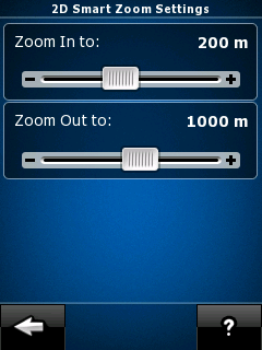
Figure 23: Smart Zoom configuration parameters.
TMC (Traffic Message Channel) support
TMC is an FM-radio based service where information regarding traffic jams, accidents, and other 'events' are transmitted on a regular basis, to allow navigation systems to route you around those problem areas. As with OCN6, support for TMC is included, but unfortunately, I wasn't able to test this out, since my HTC Kaiser/Tilt doesn't have the radio and TMC is only available in Toronto, Ottawa and Montreal in Canada. From the Wikipedia entry it appears there's a pretty good spread of TMC support in the US. but the documentation from Easy PocketNav says that TMC is not supported in US or Canada. Text to Speech (TTS) support
Text to Speech is a relatively new feature to navigation systems, designed to keep the driver's attention focused on the road by announcing upcoming events including the name of the affected street. TTS isn't shipped with the standard OCN8 product, since it can only be supported on devices with 128mb of memory or more. To get the TTS version of the product, just contact Easy PocketNav with a request, letting them know which device you have and what type of OCN card you have. What will be sent back is a new set of files to be installed on the card (be sure to back it up first!) and an updated SYS.TXT file for the OCN8 folder on the device. After restarting OCN8, you select the Susan - TTS voice profile and you're all set. (Unfortunately, TTS support is currently only in English and only for the one voice profile.) After using this for about a week, I found it to be semi-useful. The voice prompts were quite a bit choppier than the Dave 2.1 profile I had been using earlier, and while it didn't have the robotic qualities of text readers of the last generation, there were a number of syllables used in pronunciation of street names which were badly mumbled. (e.g. 'mar' at the end of "Delmar" came out more like a very short 'mer', so the street name sounds like "Delm") It had some difficulties with some of our First-Nations street names such as "Saanich, Esquimalt, and Nanaimo", but who wouldn't? It did just fine with the more English-based "Wilkinson and Hastings", but with a bit of a Cockney tendency to drop the "H" sounds. Not a bad first attempt and quite usable for most of the streets around Victoria, but the choppy flow and clipped syllables can be a bit distracting. I also found that it would frequently correct itself mid-instruction (e.g. start to say "Right..." then change it to "Left Turn"). POIs
Points of Interest are either the bane of your existence or absolutely essential, depending upon how you use your navigation system. Basically, they are stores, services and other things of interest that are pre-loaded and located into the navigation maps. Not sure where the nearest bank machine or coffee shop is? Just look it up and you'll get a list of your favorites, in order of proximity to your current location! At least that's the way they sell it. With many systems boasting installation of millions of POIs, its easy to see how they could become overwhelming if not managed efficiently. And what about those 'special' POIs which you want to maintain, like Grandma's house? Or a favourite little trysting spot? How do those getting added and managed amongst the millions of others? 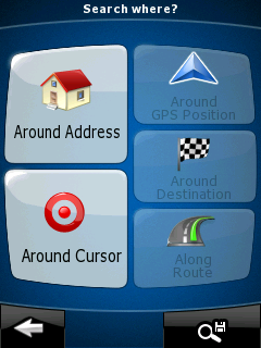
Figure 24: Options for looking for a Point of Interest. You can look around a given address, your current location, anywhere on the map you point, around your destination, or along the current route, if you have one defined.
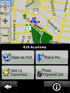
Figure 25: Tapping on a point on the map gives you the option to set it as a Favorite, a POI, the location of a SpeedCam, or just add a Pin for later reference.
When you save your own POIs, you can add them to existing categories or assign them to your own named categories, to make them easier to find. Easy PocketNav's website claims that OCN8 on the 2Gb card contains over 284,000 POIs which sounds pretty low when compared to others claiming numbers in the millions. (Edit -- Easy PocketNav has now updated this to 12.3 million POIs -- 11.2 million in the US and 1.1 milliion in Canada) The POIs provided for my small neck of the woods are as complete as any I've seen with any nav system. It certainly contains some of what I would consider some of the more obscure ones -- like bible and scout camps, local mom&pop hardware and bicycle shops, and even some businesses which are being run out of people's homes. One of the biggest complaints from OCN6 was that a feature to translate your contact information into personal POIs didn't work all that well. In almost 90% of the cases, because the address or street name wasn't formatted correctly, nothing would get created. I'm happy to report that with OCN8, the algorithm has been greatly improved and even the error handling is better. Now, over 70% of my 200+ contacts got translated to POIs and of those that didn't work, OCN8 presented a screen of options for each contact from which I could select the appropriate one. In most cases, it was due to house numbers not being provided or not exactly as recorded in the map data. Unfortunately, this error-correction process seems to be a one-shot feature, since there doesn't seem to be any way to come back to this list later or have OCN8 re-check your contacts. Documentation
Both a Quick Start Guide and a full User Manual come with OCN8, and are also available on the OnCourse Navigator website, if you'd like to take a look through the product before you buy. The Quick Start Guide describes the basics of installation and getting going with the product, while the User Manual provides a full description of all the features available. I found the User Manual to be quite well written and very readable, providing 'how to' instructions for the features of navigation and route management, then focussing on describing the icons and features of each screen. Both manuals provide lots of screenshots to show how things will look.
Conclusion
It's always difficult to take an application which is working well and try to make it better. But NavNGo and Easy PocketNav have done a excellent job in bringing OCN to the next level -- improving both the functionality and usability of the product. While I wasn't able to take advantage of the 'wow' features built into this latest version (3D graphics, TMC and TTS), the layout and accessibility of the new system certainly make it a very worthwhile upgrade for the cost. It's still my preferred navigation package.
I have to admit that (as you can see from the screenshots) I was quite used to running my nav software in portrait mode, since that's the way I normally hold my PDA, but OCN8's landscape mode is pretty intuitive and is making a convert of me. It means a bit more work figuring out a new mount for the vehicle, but layout and usability are far superior.
Don is an Associate Director with Fujitsu Consulting and the lead of its Enterprise Mobility Practice. It used to be I just needed my PPC to keep up with the kids activities -- now, I need a GPS system as well to keep up with all the different places they need to go!
__________________
/drt
|


 Linear Mode

