
02-18-2004, 06:30 PM
|
|
Review Coordinator Emeritus

Join Date: Dec 2005
Posts: 451
|
|
 Are We There Yet? - PowerLOC's Destinator 3 (v3.0.04) Reviewed
If it�s true that competition is a good thing, then things are great in the GPS navigation software category for Pocket PCs. Many fine products are available, new releases are frequent, and the products get better with each release. PowerLOC�s Destinator has been among the top players in this category for several years, and their latest version, Destinator 3, is part of their ongoing effort to remain a top player. With a redesigned interface and many new features, Destinator 3 is certainly improved, but is it the right choice for you? Let�s take it for a spin.

I reviewed Destinator 2 a little over a year ago for another site, and I liked it quite a bit. As with any software, there were areas that could be improved, and since I had reviewed other navigation products of a similar vintage, I came to the conclusion that all of the products were still in the process of maturing. So I was very interested to find that PowerLOC had released their latest update, Destinator 3 (version 3.0.04). Naturally, I was curious regarding where the product had been changed and improved. And I also wanted to find out if any of my issues with the previous version had been addressed.
Time for another road trip!
Installation and Setup
Installation was pretty much standard issue. As with all products of this type, there�s a PC component as well as the Pocket PC component. The PC component is required to select and create maps and send them to the Pocket PC.

Figure 1: US/Canada map selections.
The maps are a bit more manageable than in the previous version. The sections of the country are larger, so you can get more maps with just one selection.

Figure 2: Drag to create a custom map.
Of course, the maps aren�t particularly small, so Destinator provides the ability to create your own maps. Just load one of the standard maps and drag an outline around the area that you wish to include.
Once you have the desired maps selected or created, Destinator provides the means to copy them to your Pocket PC or some other storage device. The standard map that includes my area (USA2) requires 199 MB of storage, so you�re obviously going to need a storage card for that. Even a smaller version that I created, including southeastern Wisconsin and the Chicago area, required 51 MB. You can copy the maps using ActiveSync, but if you�re going to do a lot of large maps, I�d recommend using a card reader� it�s MUCH faster.
With the size of the maps, it could be difficult to plan a longer route, not only because of the large maps but also because Destinator only allows one map in memory at a time. However, a new feature is a specialized map called USAROADS, which provides all major roads in the US. I mapped a route from the Milwaukee area to Monterey, CA with no problems at all. Of course, you don�t get all of the detail on this map, but it�s a key addition for improving Destinator�s overall functionality.
Installation on the Pocket PC is also �standard operating procedure�. One additional thing that you have do deal with is getting Destinator and the GPS unit to communicate. Destinator makes this easy since it has the capability of finding the GPS. It takes a few minutes, but it eliminates the need to connect to the GPS via trial and error. I used my trusty NavMan 3420 (an iPAQ sleeve) with my iPAQ 5455, and they worked together just fine, once I downloaded a necessary serial driver for the iPAQ from the Destinator site. I had to do this with the previous version as well, but this is a Compaq/HP issue, not a Destinator issue.

Figure 3: Satellites acquired.
Figure 3 shows the GPS status screen. This shows the number of satellites that have been acquired and other information, such as longitude and latitude, altitude and velocity. In general, the more satellites acquired, the better. First, only a 2D fix is available with a smaller numbers of satellites (horizontal position only, not altitude)� a 3D fix will give you accurate altitude as well. Also, if one or more satellites is blocked by a tree or building, a larger number of satellites makes it easier for the GPS to switch over to another satellite to replace the blocked one.
If you�re interested in more information about how a GPS works, this article is very informative.
Planning a Route

Figure 4: The Destinate menu (nice menu, bad English� ).
To set up a route, you use the Destinate Menu. As with Destinator 2, origins and destinations can be designated through their addresses, chosen from a list of POIs (Points of Interest), or from your Contacts list. You can also save a location as a Favorite if you use it often. Finally, you can refer to the History list to select a location that you used previously.
Two things that stood out to me immediately are the improved menus and overall appearance of Destinator. As I used it more, I found the menus to be much better organized, and I spent much less time searching for features. With the large colorful icons, Destinator 3 leaves the more utilitarian look of Destinator 2 behind, and sports an attractive design that�s clearly inspired by Windows XP.

Figure 5: Pick your city.
Back to �destinating�� specifying an address is a simple �wizard-like� process. First, choose the city.

Figure 6: Destinator is �street smart�.
A list of streets for the chosen city will display. Make a choice from this list.

Figure 7: It�s got your number.
Destinator will show a range of valid numbers for that street. Enter the number, and if it matches, you�re done! Tap on the Navigate icon in the toolbar and Destinator creates your route.
Additional options for specifying addresses include ZIP and Street and Intersection. The latter is useful if you don�t have an exact address, but know a nearby intersection.

Figure 8: Categories for Points of Interest.
POIs were a strength with Destinator 2, and that still holds true for Destinator 3. A wide range of categories is provided from which to choose.

Figure 9: Display only your favorites.
Some categories, such as Hotel, have popular chains available, so if you�re stuck on Motel 6, you can display all Motel 6 locations in the general area. (And if you�re stuck on Motel 6, just call the main desk... it's most likely just something that housekeeping missed...)

Figure 10: Some great places to stay.
When you expand the item list for the POI, you see the available choices. You can sort by mileage from your current location or alphabetically.
By the Time I Get to Phoenix

Figure 11: Let�s spend the afternoon at the Club�
So let�s say you�re all set to leave for Wally World, but you have to make slight detour to drop Aunt Edna off in Phoenix. With Destinator 3, you�re all set for both legs of your trip, because it now supports waypoints.
With waypoints, you can specify your origin, multiple intermediate destinations and your final destination. Destinator will determine a route between consecutive waypoints, so that you can make your way to Phoenix first and then to Wally World. This was on my wish list from the Destinator 2 review (the waypoints feature, not a trip to Wally World), so I�m happy to see that it made it into this version.

Figure 12: Turn-by-turn view.
Once the route has been calculated, you can look at the results in a variety of ways. Turn-by-turn shows the map display for each turn, with the distance from the previous turn. Note the new �fly-out� direction arrows on the map� they�re much more legible than in the previous version.

Figure 13: Destinator understands the male psyche... never ask for driving directions again!
Driving directions are also available. In this view, a list of all turns is provided, and no map is displayed. If you�d like to see a particular turn, tap on the Show icon and you�ll see the corresponding map from the turn-by-turn display.
From this view, you can see another important addition to Destinator 3� the ability to avoid roads. If you don�t want to use a particular road that Destinator selects, highlight it and tap on Avoid. The route will be recalculated, and that road will no longer be used.
You can do this on a route-by-route basis, or you can pre-designate roads that you always wish to avoid, so Destinator will always avoid them.

Figure 14: The whole route.
Destinator can also display your entire route, along with total distance and estimated time of arrival.

Figure 15: Tap and hold.
Another added convenience� Destinator now provides convenient �tap and hold� menus in many map views.
As with the previous version, Destinator 3 allows you to use flat 2D maps as well as 3D maps with an �over the shoulder� view. Since they have greater detail, I generally used the 2D maps except in unfamiliar areas, where the larger view provided by the 3D maps sometimes makes it a bit easier to get your bearings.
Let�s Motor!

Figure 16: Rollin', rollin', rollin'...
When you�re on the road, Destinator can display your route as a map (Figure 16) or as a series of directions (as shown in Figure 13). Your next turn is shown on the top, along with the distance to that turn. The gray strip just below the map alternates between four displays: latitude/longitude, velocity/altitude, estimated time of arrival/estimated time remaining, and distance to destination. Any of the four displays can be turned off.

Figure 17: �In your face� directions are a good thing.
Another new feature that I like is the large turn alert that comes up on the screen when the verbal turn alerts are announced. If you glance at the screen when you hear an alert, you�ll see this large display that very clearly indicates the direction of your turn, the distance to the turn, and the road onto which you�re turning. This is just one more feature that Destinator provides to give you as much information as possible, quickly and with minimum distraction.
So how are the routes that Destinator 3 creates? For the most part, they�re great, especially when dealing with interstate highways. However, I was a bit disappointed with Destinator�s routing when you need to drive into an area with lots of side roads. For some reason, it has a real affinity for back roads and lots of turns. This generally isn�t an issue until you get close to your final destination.
For example, I set up a route from Milwaukee to the IKEA store near Chicago. Most of the route was what you�d expect, using interstate highways and tollways. But once the route got within about 10 miles of IKEA, Destinator had us exiting the tollway and following a circuitous route of highways, with way too many turns. This stood out in contrast to a route that another person on the trip had created on MSN, which was much more direct. I thought this might have something to do with having �Shortest� set rather than �Quickest� for the route, but the route that Destinator created as we neared the destination was circuitous regardless of the setting.
To test this further, I decided to do an experiment with a local route to a relative�s house about 13 miles from home. On the Quickest setting, the route that Destinator created consisted of 13 different roads and many turns. On the other hand, a route created using Pharos Ostia used four roads and far fewer turns. In fact, Ostia created the exact route that I normally take. As did the mapping service on MSN. And the mapping service on Yahoo. And MS Streets and Trips 2004. The route created by Destinator was about � mile shorter, but with the slower roads and the number of turns and stop signs involved, there�s really no way it could have been quicker than the routes provided by these other products.
Destinator is the fourth navigation product that I�ve reviewed, and over the span of these reviews, I�ve realized that you can�t penalize a product simply because it doesn�t take the same local route as you would. But the issue with my test was not that Destinator didn�t take the same route, but that it created a route that covered so many back roads with so many turns. So it seems to me that Destinator�s routing algorithm would benefit from some fine tuning.
Of course, when using Destinator to go to an area with which you�re unfamiliar, you may not notice if the route near your destination becomes a bit circuitous.

Figure 18: The scenic route?
I ran into one other routing anomaly with Destinator 3. In Figure 18, the route calculated by Destinator is the blue and white line. Notice that it took me off of a particular road on to two other roads, only to shuttle me back to the same road. Why it didn�t just continue on the same road is a mystery. I don�t claim to remember a whole lot from high school geometry, but I do recall enough about the Pythagorean Theorem to realize that this little detour barely saved any distance or time.
Since I used several paragraphs to describe these issues that I uncovered, I do want to emphasize that the routes created by Destinator are generally of very good quality. I just would encourage the designers to look at the product�s tendency to overuse back roads and create routes with more turns than necessary.
As for other features, Destinator 3 still provides the very useful advance warning that I liked so much in Destinator 2. Unlike some other products, if you�re on a long stretch with no turns, Destinator will notify you of an upcoming turn two miles in advance. That�s in addition to the standard early warning (generally around 200 yards in advance� this distance increases as speed increases) and the final directive to actually make the turn. I missed this feature in Ostia, which provided only the shorter early warning. You appreciate Destinator�s advance warning particularly in heavier traffic� it gives you plenty of time to make necessary lane changes to prepare for your turn or exit.
Another new feature that I like is the new skinning capability. Destinator includes skins for day color maps and night color maps. The night color maps display the roads in high contrast on a dark background, making them easier to read in low light. The capability to add skins is also included, though I was unable to find any other skins during the review.
Gotchas
At the risk of beating these issues to death, here's a recap:
- Occasional tendency to overuse circuitous back road routes;
- Isolated case of illogical routing.
Where To Buy
Destinator 3 can be downloaded for $199, which includes the software and US/Canadian maps. [Affiliate] Maps of Europe are also available.
Specifications
According to PowerLOC, Destinator 3 is compatible with most Pocket PCs, including older models such as the Cassiopeia E-125 and early Jornadas. It supports GPS receivers that can connect to your Pocket PC through the serial port, the CF card slot or via Bluetooth and are compatible with the common NMEA and SiRF protocols. Installation requires approximately 4 MB of storage space, not including maps.
Conclusions
As with previous versions, Destinator 3 is an impressive piece of navigation software, very capable and very powerful. The latest version provides a much improved interface and such useful new features as multiple waypoints and the �avoid roads� functionality. The only thing that keeps it from being �nearly perfect� is the �tour of the back roads� routing issue that occasionally surfaces. But in most cases, the routes are great. When you�re traveling, the customized routes that Destinator provides will make your trip much more enjoyable and far less stressful. And with the kids in the back seat screaming �Are we there yet? Are we there yet?�, a little less stress is a welcome thing.
UPDATE (03-29-2004): The folks from PowerLOC were concerned about the routing issues that I reported in my review, and they supplied me with an updated version of Destinator 3 which they felt would address my concerns.
The update was quite successful... the little routing glitch that took me off of my main highway path was corrected, and the tendency for side road routes to become overly complicated was reduced. Overall, the fine tuning in this version was evident, and addressed any reservations that I had about the product. I can now give it my full endorsement.
|
| |
|
|
|
02-18-2004, 06:58 PM
|
|
Magi
Join Date: Sep 2005
Posts: 2,341
|
|
Excellent review Doug!
I'm using Destinator3 myself at the moment for a review, and I would agree with your findings. Particularly the "in town" routing. It takes far to many turns and twists. I think it would be perfect if they offered a third routing choice besides, quickest and shortest....EASIEST!
Otherwise it is great!
Dave
|
| |
|
|
|
02-18-2004, 07:45 PM
|
|
Review Coordinator Emeritus
Join Date: Dec 2005
Posts: 451
|
|
Thanks, Dave!
Easiest... that's exactly what I'm looking for as well. It would be a welcome improvement to an otherwise outstanding product.
|
| |
|
|
|
02-18-2004, 10:20 PM
|
|
Ponderer
Join Date: Jul 2003
Posts: 75
|
|
Dave,
A great review !
I gotta say though, no matter what the quality of the rest of the product. If the routing is not up to the task then sorry.... no purchase. I can easily get myself from Milwaukee to Chicago, its when I'm in the "downtown don't know the streets very well" areas that its absolutely critical the software routes best.
Sorry PowerLoc Destinator, not going to get my cash until those problems are fixed.
Thanks for the honest & open review. This (and so many others) is the reason why PPC Thoughts is the greatest
Steve.
|
| |
|
|
|
02-18-2004, 11:25 PM
|
|
Review Coordinator Emeritus
Join Date: Dec 2005
Posts: 451
|
|
Quote:
|
Originally Posted by garrans
Dave,
A great review !
I gotta say though, no matter what the quality of the rest of the product. If the routing is not up to the task then sorry.... no purchase. I can easily get myself from Milwaukee to Chicago, its when I'm in the "downtown don't know the streets very well" areas that its absolutely critical the software routes best.
Sorry PowerLoc Destinator, not going to get my cash until those problems are fixed.
|
Well, my friends call me Doug... :wink:
Agreed, when the rest of the product is so well crafted, the complex "close to destination" routing is disappointing. I hope that this may be a matter of fine tuning the algorithm, because I like the rest of it a lot.
Quote:
Thanks for the honest & open review. This (and so many others) is the reason why PPC Thoughts is the greatest
Steve.
|
Thanks, Steve... honest and open is what I strive for. I figure that if my reviews aren't honest, they aren't of any use to anyone.
|
| |
|
|
|
02-18-2004, 11:34 PM
|
|
Theorist
Join Date: Apr 2004
Posts: 262
|
|
Very nice review, acouple of remarks about the product :
1) every screen has a nice designed GUI (gps settings, menu's etc...), but the navigation window itself looks so Windows 3.11 compared to TomTom Navigator 2 (which I'm using at the moment).
2) No GPS solution can have the best routing all the time, now I use TomTom in my own car and two different VDO systems in other cars I frequently use, and all of them sometimes take a strange route. Sometimes it's easy, sometimes the route scare the heck out of you. Today TomTom navigated me through all of these farm roads witch ditches at eather side. The road was bearly big enough for one car and it was a two direction road with tractors and stuff going each way ! Really, I almost **** my pants driving there. When I got home, I checked on Route 66 and it seems like there's a large road that I could've use but apparantly TomTom likes the dangerous side ;-) All these downsides don't matter too much, it's technology, it can fail, but it's nice to have a buddy that can guide you , even though it can be strange 
Kind regards,
Ivan
|
| |
|
|
|
02-19-2004, 04:20 AM
|
|
Intellectual
Join Date: Mar 2004
Posts: 209
|
|
After using D2-Routis 2004-D3. My comments:
1-D3 does not support gated community destinations (same problem with Pharos). Strange problem knowing Routis & D3 are using the same Navtech map. Routis works perfectly. And Pharos is using TeleAtlas, it has the same problem. Go figure!
2-I first complained about D3-3-D view w/o street name like Routis. But actually it is not bad if you think about getting to your destination and not worry about the surroundings. It gives you the route to get there clearly.
3-D3 does not offers most consistent user interface ..You can pretty much use Routis/TT2 it without the stylus and the navigation between screen is fairly intuitive, where D3 requires a mix of stylus & finger, buttons are also mix size: large, small, standard PPC keyboard....The navigation between screen takes time to get used to.
4-The D3 small rotation info in the bottom bar is poorly designed, could be a safety hazard if you don't turn off the automatic scrolling.
5-D3 Lack of info such your destination on left & right of the street is irritating. Lack of showing address of destination when it is reached is also regretable.
6-The 2-D map of D3 is just spectacular. D3 also allows spanning map with your finger in all direction. It is great. D3 Auto map zoom based on speed is also very convenient.
7-The registration scheme of D3 is very very cumbersome, if you have more than 1 PocketPC or you change often PDAs...You will expect several phone call to D3 support...
8-The selection destination from your contact database works very well with D3
(I already posted this on PocketPCPassion.com)
|
| |
|
|
|
02-19-2004, 07:30 AM
|
|
Magi
Join Date: Sep 2005
Posts: 2,341
|
|
Quote:
|
Originally Posted by garrans
Dave,
A great review !
|
Thanks!  :wink:
|
| |
|
|
|
02-19-2004, 05:40 PM
|
|
Pupil
Join Date: Apr 2004
Posts: 27
|
|
I use my Pocket PC every day, but didn't want to tie it up in the car or hiking with GPS. I just got the Garmin IQue 3600 to use pretty much as a pure GPS - not for the Palm OS functions. It is fantastic, and the maps look wonderful on the IQue's 320x480 screen. Completely satisfied. I look at it as having saved about $400 over Garmin's other high-end dedicated units, and the IQue has a better display.
I've just never been impressed with GPS add-ons for either Palm or Pocket PC, but very nice review of Destinator.
|
| |
|
|
|
02-21-2004, 08:52 AM
|
|
Swami

Join Date: May 2004
Posts: 4,396
|
|
Bad Routing
Quote:
|
Originally Posted by garrans
I gotta say though, no matter what the quality of the rest of the product. If the routing is not up to the task then sorry.... no purchase. I can easily get myself from Milwaukee to Chicago, its when I'm in the "downtown don't know the streets very well" areas that its absolutely critical the software routes best.
|
Actually, I think the most important thing is that it gets you to your destination. The routes chosen sometimes aren't the best, but sometimes they are shorter than the obvious ones. Even if it takes a bit longer to get to the destination, unless you're in a hurry, it probably won't matter most of the time. It would be nice if a "minimize number of turns" option was offered, though. (CoPilot Live offers a Vehicle Type option, which minimizes sharp turns if you're in an RV.)
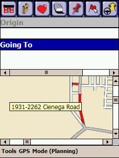
That said, sometimes the routes are bad because map data isn't correct. I use CoPilot Live, and I know of one instance in my area where a road is shown that doesn't exist or a road is shown that actually had ended. (The roads in red in the image shown here.)
That said, imagine how a computer must deal with this. First, somebody has to create accurate mapping data (and somehow keep it up to date). Then, the computer has to take that data and compare what could be a very large number of possible paths from one point to another. Even if it gets the shortest route there, to get the quickest route, it must then know what kind of roads the route uses, where one-way streets are and even where stop signs or stop lights are (I'm not sure most GPS programs actually know where stops are).
In computer science, plotting the shortest route between several stops is considered a computationally complex program (if I remember my terminology, it's NP Complete, meaning the difficulty is thought to increase exponentially).
For all their flaws, current GPS programs do a great job. I drove from Hollister, CA to Las Vegas to Hoover Dam to Tonopah, AZ, to Bakersfield, CA and back to Hollister without using any paper maps, just CoPilot Live. (I did check my routes before I left using Microsoft Streets & Trips to ensure the routes were similar, but, in the car, it was all CoPilot Live.) There were some places that CoPilot Live confused us in Bakersfield (where roads that appeared to go straight stopped at a railroad track, and we didn't see the overpasses for a while), but overall it worked pretty well.
Consider what could happen with a bad GPS navigation system. On a trip from Los Angeles to Miami, you could end up going through Chicago. Oh wait, that sounds like the airlines. :lol:
Steve
|
| |
|
|
|
|
|


 Linear Mode

