 Google Maps 5.0: See It Now In 3D!
"I'm excited to announce Google Maps 5.0 for Android, with two significant new features: 3D interaction and offline reliability. We launched Google Maps for mobile a little more than five years ago. Since then, we've added dozens of features, and we've grown from a few thousand to more than 100 million users. Still, a couple of things have remained the same: a flat, north-up map and the need for a strong Internet connection. Today, we're changing that for the first time." 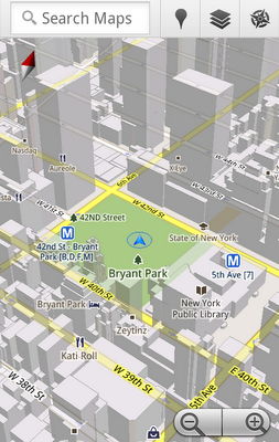
Google Maps for Android just got really freakin cool. (Not that it wasn't cool enough already.) Version 5.0 brings quite the list of exciting features to the table. The biggest change in my mind is the switch to vector based graphics, think PDF vs. JPG. While Maps still uses tiles of map data each tile now contains the information required to render any zoom level of that location. Which means once you've cached that section of the map you will not have to download any more data regardless of zoom level. Previously each zoom level had it's own static image that you needed to download when you zoomed in or out. According to Google this has reduced the size of the map data by 100 times. Which leads us to possibly the best new feature of all, offline rerouting and better offline reliability. With the massive reduction in map data size Google is now able to cache much more data very quickly. They are still in the early stages of rolling this out behind the scene but soon you will be able to setup your route and go without having to worry if you will loose data connection along the way and get lost. A few of the other great features include support for those cool 3D buildings we see on the full web version as well as tilting and rotating of the map using either gestures or the compass. So, what are you waiting for? Go get it NOW!
|


 Threaded Mode